![]()
Photos by Bill Pitts
DRIVING DIRECTIONS TO MISSISSIPPI'S CLARK CREEK NATURAL AREA

Clark Creek Natural Area is in an extremely remote location, and medical and other assistance can be a long way off (my cell phone didn't work in the area). Be careful, watch your footing on the steep trails and around the waterfalls. Remember that poisonous snakes and the occasional black bear can be found here. There is no potable water or toilet facilities. You'll need to carry water with you, especially during the hotter times of the year. Plan your trip carefully, and take a map and compass if you intend to try the Primitive Trail. Remember insect repellant and avoid using this trip to break in your new hiking boots. Don't overextend yourself and you should have a very enjoyable trek. And as the sign says, "Hike at your own risk."
DIRECTIONS:
 Clark Creek Natural Area can be found in the southwest corner of Wilkinson County in southwest Mississippi, thirteen miles west-southwest of historic Woodville, in the community of Pond. Jackson is about 140 miles (by road) to the northeast, Baton Rouge is roughly 55 miles to the south, and Natchez about 48 miles to the north by U.S. 61
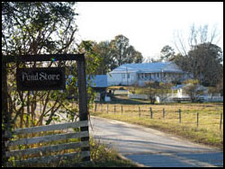
From Jackson, visitors can take Interstate 55 south to McComb. Proceed west on Highway 24/48 to Woodville (take care to watch for the turn for Highway 48 in Liberty—I was rubber-necking and followed Highway 24 nine miles out of my way through Gloster). Continue through Woodville on Highway 24, and at the Clark Creek sign (about one mile after crossing the famous Highway 61), turn left onto the Woodville-Pond Road. Drive 13.6 miles to the community of Pond, watch for the Clark Creek sign and turn right. Proceed across the cattle gap up toward the Pond Store, the large, white building just past the ponds. Directions are available at the store or continue past the store to the parking area just up the road on the left, about 200 yards.
From Natchez, follow Highway 61 south to Woodville, turn right onto Highway 24 and, again, at the Clark Creek highway sign, turn left onto the Woodville-Pond Road. Drive 13.6 miles to the community of Pond, watch for the Clark Creek sign and turn right. Proceed across the cattle gap up toward the Pond Store, the large, white building just past the ponds. Directions are available at the store or continue past the store to the parking area just up the road on the left, about 200 yards.
From Baton Rouge, take Highway 61 north, past St. Francisville, Louisiana. Turn left on Angola Prison road, otherwise known as Highway 66. Eventually, Highway 969 will fork off to the right, Turn right there, otherwise you'll end up at the prison! Watch for the Clark Creek sign after about 7.3 miles. Proceed across the cattle gap up toward the Pond Store, the large, white building just past the ponds. Directions are available at the store or continue past the store to the parking area just up the road on the left, about 200 yards.
Alternatively, you can drive north on Highway 61 to Woodville and turn left onto Highway 24. At the Clark Creek highway sign, about one mile down Highway 24, turn left onto the Woodville-Pond Road. Drive 13.6 miles to the community of Pond, watch for the Clark Creek sign and turn right. Proceed across the cattle gap up toward the Pond Store, the large, white building just past the ponds. Directions are available at the store or continue past the store to the parking area just up the road on the left, about 200 yards. This is a longer drive but some may feel more comfortable taking Highway 61.
Once you arrive, you'll want to be able to find your way arround. Click here to see our map of the Clark Creek Natural Area.
IMPORTANT NOTE:
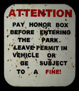
There is a Day Use Permit fee for Clark Creek Natural Area that is paid using the honor system. Look for the envelopes in the small shed to the left of the trailhead. Follow the directions, pay the fee, and you avoid the risk of a fine.